Home » The Regional Centre for Mapping of Resources for Development (RCMRD) – Nairobi
The Regional Centre for Mapping of Resources for Development (RCMRD) – Nairobi

SURVEILLANCE ET ÉVALUATION DE LA DÉGRADATION DES SOLS ET DES ZONES HUMIDES EN AFRIQUE DE L’EST
L’objectif principal du projet GMES & Africa du RCMRD est d’améliorer les moyens de subsistance des communautés africaines en soutenant le processus de prise de décision à l’aide de données d’observation de la Terre.
Responsable du Consortium : Le “Regional Centre for Mapping of Resources for Development” (RCMRD) – Nairobi.
Couverture Géographique : Les iles Comores, Djibouti, Erythrée, Ethiopie, Kénya, Rwanda, Sud Soudan, Soudan, Tanzanie, et Ouganda.
Orientation : Il est axé sur les priorités suivantes du programme :
- Surveillance et évaluation de la dégradation des sols;
- Surveillance et évaluation des zones humides;
- Base de données vectorielles de référence régionale géographique accessible pour les zonages hydrologiques et agroécologiques.
Celles-ci sont mises à la disposition des décideurs et des utilisateurs finaux afin de permettre aux communautés de modifier positivement leurs moyens de subsistance. Ces informations sont essentielles à la formulation des politiques de la région et à la gestion durable des ressources naturelles.
Site Web : https://gmesgeoportal.rcmrd.org
LAND DEGRADATION AND WETLAND MONITORING AND ASSESSMENT IN EASTERN AFRICA
The primary goal of the GMES and Africa project at RCMRD is to improve the livelihoods of African communities by supporting the decision-making process using Earth observation data.
Consortium Leader: The Regional Centre for Mapping of Resources for Development (RCMRD) – Nairobi.
Coverage: Comoros, Djibouti, Eritrea, Ethiopia, Kenya, Rwanda, South Sudan, Sudan, Tanzania, and Uganda.
Focus: The project focuses on the following programme priorities:
- Land Degradation Monitoring and Assessment
- Wetlands Monitoring and Assessment
- Open Geographical Regional Reference Vector Database for Water and Agro-Ecological Zonings.
These applications are available to decision-makers and end-users to empower communities to change their livelihoods positively. This information is critical to the region’s policy formulation and sustainable natural resource management.
Website: https://gmesgeoportal.rcmrd.org
Publications

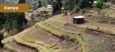
Application of Land Degradation Index Map (LDIMs) in identifying degraded areas for National Tree Planting
Land degradation denotes a decline in land productivity including agricultural production and is a serious problem in Africa, affecting every facet of the economy.