

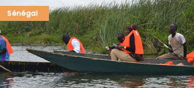
Support for the fishing community in the Tocc-Tocc Community Natural Reserve in Senegal by regularly monitoring the dynamics of invasive aquatic plants
As part of the implementation of the GMES&Africa Program, the Centre de Suivi Ecologique (CSE), has been coordinating the Sustainable Management of Wetlands for the Strengthening of Food Security and Ecosystem Resilience in West Africa (GDZHIAO) project since 2017.
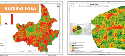
Supporting Local Municipalities of Bobo-Dioulasso and Ouagadougou to Deal With Vulnerability to Flooding
This use case details the consortium’s engagement with end-users in Burkina Faso to support them in analyzing climate change mitigation, adaptation, and managing flood risks. Two municipalities, Bobo-Dioulasso and Ouagadougou, were identified to implement the work.
Support for the fishing community in the Tocc-Tocc Community Natural Reserve in Senegal by regularly monitoring the dynamics of invasive aquatic plants
As part of the implementation of the GMES&Africa Program, the Centre de Suivi Ecologique (CSE), has been coordinating the Sustainable Management of Wetlands for
Supporting Local Municipalities of Bobo-Dioulasso and Ouagadougou to Deal With Vulnerability to Flooding
This use case details the consortium’s engagement with end-users in Burkina Faso to support them in analyzing climate change mitigation, adaptation, and managing flood